


les terriers les arcs

Edith Messiaen
User
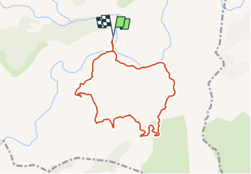

Length
8.5 km

Max alt
259 m

Uphill gradient
259 m
Km-Effort
12 km

Min alt
30 m

Downhill gradient
258 m
Boucle
Yes
Creation date :
2022-01-03 08:03:00.188
Updated on :
2022-01-03 10:57:24.815
2h53
Difficulty : Medium

FREE GPS app for hiking
 SityTrail
IGN / Geographical institutes
SityTrail Plus
The world is yours!
About
Trail Walking of 8.5 km to be discovered at Provence-Alpes-Côte d'Azur, Var, Les Arcs-sur-Argens. This trail is proposed by Edith Messiaen.
Description
rando
Positioning
Country:
France
Region :
Provence-Alpes-Côte d'Azur
Department/Province :
Var
Municipality :
Les Arcs-sur-Argens
Location:
Unknown
Start:(Dec)
Start:(UTM)
298508 ; 4812032 (32T) N.
Comments